The Motivation: The phenomenon of illegal dumping is one of the most serious environmental and social problems in Cyprus. Illegal dumping degrades the natural environment, creates public health risks, contributes to the deterioration of the country’s natural landscapes and has a negative economic impact on vital economic sectors such as tourism.
To address the issue, PERIOPSIS has developed a pioneering service, DumpMapper, that uses high-resolution satellite imagery and computer vision techniques for early detection of illegal waste. DumpMapper provides the exact location of all dumping sites in a given area via the PERIOPSIS Portal, together with a suite of tools and insights that allow municipalities, cleaning companies and other beneficiaries to better monitor and manage illegal dumping in their areas of responsibility, fostering a proactive and comprehensive approach to waste management.
Understanding where dumping occurs is crucial for developing effective strategies to combat this issue. In our efforts to better understand the distribution and characteristics of illegal dumping sites, we sought to analyze various environmental and human factors that might influence where dumping is more likely to occur. We aimed to uncover patterns related to proximity to infrastructure, as well as the relationship between land use types and dumping frequency. By examining these factors, we hoped to gain deeper insights into the underlying causes of illegal dumping that would guide more effective interventions.
The Method: The recent release of GAEA, a new tool with geospatial data of Cyprus developed by the SuPerWorld research group of the CYENS Center of Excellence, offers new opportunities for analyzing and understanding dumping locations, allowing us and our customers to identify trends that were previously difficult to detect.
Leveraging the API of GAEA, we have embarked on a project to characterize illegal dumping sites we have identified as part of our pilots with municipalities in Cyprus. In total, we examined 757 dumping incidents across the municipalities of Nicosia, Larnaca, Lakatamia, Ypsonas and Livadia and adjacent areas. An overview of the incident we examined can be seen in the table below:
|
Municipality |
Size (km²) |
Incidents |
Incidents per km² |
|
Nicosia |
50,3 |
73 |
1,45 |
|
Larnaca |
32,8 |
26 |
0,79 |
|
Lakatamia |
27,4 |
142 |
5,18 |
|
Ypsonas |
32,4 |
337 |
10,41 |
|
Livadia |
8,7 |
28 |
3,23 |
|
Other |
– |
151 |
– |
|
TOTAL |
|
757 |
|
The GAEA platform provides a suite of analytics and tools in five main categories of services: Proximity General, Land Cover, GeoHazard Landform Attributes and Weather. For this project, we utilized the three first services, aiming to explore the characteristics of dumping incidents, including elevation, slope, and proximity to roads, residential neighborhoods and natural reserves.
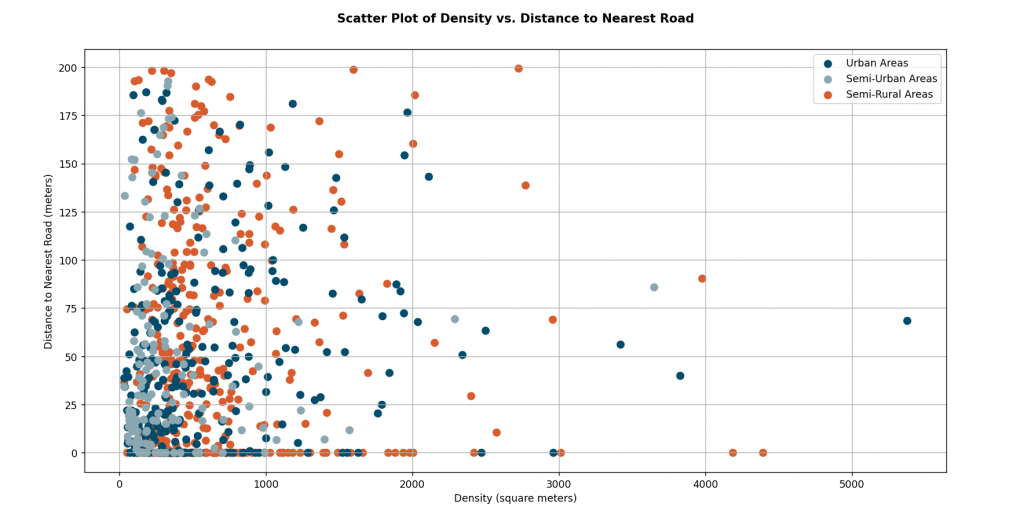
The Results: Data collected using the GAEA API reveals crucial insights into illegal dumping patterns. As you can see in the graph below, a significant number of incidents occur near roadways, particularly in urban and semi-urban areas. A notable number of dumping incidents (154 cases) were located between zero and one meter from the road (excluded from the graph for clarity).
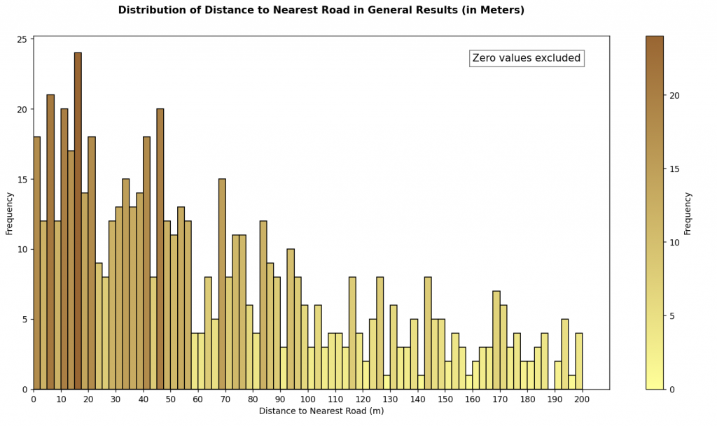
Additionally, our analysis shows a high frequency of smaller illegal dumps closer to roads in urban and semi-urban areas and a more even distribution of illegal dumping regardless of the size or distance to nearest road in semi-rural areas.
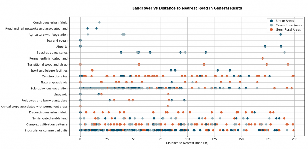
Furthermore, we have explored integrating GAEA data with other complementary services, such as QGIS, to enhance our understanding of the relationship between land use and illegal dumping. The diagram below illustrates the relationship between land use types and their proximity to the nearest road, highlighting how certain land uses are more susceptible to illegal dumping. We notice a higher frequency of dumping incidents in areas characterized as areas of sclerophyllous vegetation and industrial or commercial areas.
The Importance: Pairing the GAEA API with the insights of our DumpMapper service has expanded our understanding of illegal dumping in Cyprus. The services of GAEA allow us to broaden the information provided to our customers, empowering them to take more informed and targeted actions in regard to illegal dumping. The data-driven approach helps municipalities and other stakeholders to better predict potential future dumping sites, allowing for proactive measures to prevent illegal waste disposal. This capability is crucial for protecting the natural environment, preserving the aesthetic and economic value of the country’s landscapes, and safeguarding public health. Furthermore, the study demonstrates the potential of the GAEA’s geospatial data to be integrated with other tools and datasets and unlock the potential of existing data, providing solutions for a variety of applications.
The Perspective: The use of advanced technologies such as the GAEA API represents a significant step forward in environmental monitoring and management. As we continue to refine these tools and expand our dataset, we anticipate even greater precision in identifying and characterizing illegal dumping activities. The insights gained through this project not only highlight the immediate impact of illegal dumping but also provide a foundation for developing long-term strategies to combat it. By fostering collaboration between technology providers, researchers, and local authorities, we can enhance our collective ability to protect the environment and ensure a cleaner, safer Cyprus for future generations.
Looking ahead, the integration of GAEA with other innovative technologies holds great promise for expanding our capabilities even further. As we continue to harness the power of geospatial analytics, machine learning, and other advanced methodologies, we are committed to staying at the forefront of environmental protection. Our goal is to not only react to the problem of illegal dumping but to anticipate and prevent it, paving the way for a more sustainable and responsible approach to waste management. Together with our partners, we will continue to explore new solutions and approaches that will ensure that our efforts contribute meaningfully to the preservation of Cyprus’s natural beauty and the well-being of its residents.
This study was conducted with the invaluable contributions of our interns, Andreas Charalambous and Christophoros Kontzias, students of the University of Cyprus, who joined our team in July 2024 as part of the Research and Innovation Foundation’s 2024 Internship Programme.